Bordman Road

Bordman Road Reconstruction – City of Memphis, Michigan

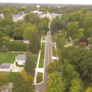
The City of Memphis is a small quiet community located on the southerly bank of the Belle River. It is on the border of Macomb County and St. Clair County, Michigan with a population of approximately 1072 people.   The City’s downtown corridor extends north, south, east and west from the intersection of M-19 (Main Street) and Bordman Road and is host to an assortment of retail stores, service businesses, light manufacturing, Memphis Community Schools and private residences.  All very typical of a rural community.

Bordman Road is the main east and west road running through the City.  The roadway within the city limits measures approximately 1.25 miles in length and is classified as a major collector.  The most recent large-scale road improvement project was concluded in 1988.  The roadway had been largely overlooked since this time and had fallen into disrepair and well beyond preventative maintenance rehabilitative measures. However, reconstruction of the entire stretch of roadway as a single project was not within the City’s financial capability.  Phasing the project over a period of several years was the logical solution but, even still, financial assistance would be needed.  On behalf of the City, BMJ prepared an application for Federal Funding through the Michigan Department of Transportation – Transportation Improvement Program Grant for the initial phase of the project.  A grant was awarded in the amount of $295,000 in 2017 for a 0.33-mile section of the road.  The City’s share of the project cost was $74,000. Construction of the roadway started and concluded in summer of 2018 at a total cost of $369,000.

BMJ provided full design engineering and construction engineering services for the project.  The design included the use of recycled materials by utilizing in-place pulverization of the existing asphalt pavement as the new pavement base course.  New asphalt leveling and surface courses, enclosed storm interceptor sewer with drainage structures, concrete curb and gutter, gravel shoulders, guardrail, large diameter cross culvert, sidewalk and driveway replacement, traffic control signage, pavement markings and lawn restoration were the primary elements of the project.

The contractor for the work was Teltow Contracting of Casco, Michigan. The project was successfully completed on time and within budget.  The City is currently in the planning stages for the next phase of the work to be completed in 2021.

The Legacy Project

The Legacy Project

Cindy Whisman and the students of St. Clair High School are raising funds for a project they have named, “The Legacy Project”. The project is designed to allow students to leave behind their “legacy” after graduation. Students will mark their legacy at SCHS by painting a rock at the end of their senior year.  The rocks will then be placed into a structure, that was designed by a SCHS student. The area designated for this structure, is located on the SCHS school grounds, in front of the counseling offices.  The goal of the project is to increase student’s ownership to their school and community, and ultimately to develop a togetherness within the graduating class as they begin the next chapter of their lives.

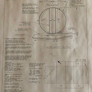
Dependent upon funding, the project is scheduled to begin spring of 2019. The project has gained support from the student body, teachers, counselors, the principal and parents of St. Clair High School. BMJ Engineers & Surveyors, Inc. has also shown their support with Senior Project Engineer, Michael W. Quaine, P.E. lending his services to aid in the calculation of the size of aluminum plate that is needed to stabilize and hold the structure. He also prepared a dimensional sketch illustrating the design. The St. Clair Woman’s League, which president Carolyn R. Hunter, P.S. is involved with, has supported the project with a monetary contribution.

“The Legacy Project’s focus is on the beautification and connectedness of SCHS”, said Cindy Whisman. Her goal is to beautify the school grounds and provide a new tradition for all the seniors to come. She hopes that when they are older and have families of their own, they will circle back to see their “legacy” as it continues to stand at St. Clair High School.

If you or someone you know is interested in donating to The Legacy Project, please email Cindy Whisman at cwhisman@ecsd.com.

“The Mastodon and the Tuscola County Drain”

Michael W. Quaine, P.E.

Imagine sometime between 11,000 to 13,000 years ago, a Mastodon wanders into a bog area on a cold spring day to feed on the local flora.  Ice clings to his hair and eye lashes.  A small pond, formed from glacial out-melt, beckons him to wade in.  A sharp stab wheels him around and he looks for a safe escape route. He staggers towards the bank of the pond and into a muddy, black, and miring mudflat swamp.  He touches his side, where the wound is wet with blood.  Caught up in the dense mud and vegetation, he closes his eyes, staggers and drops.  As the morning light rose, human hunters find him taking his last breath, partially submerged in the mucky water and unmoving.  The hunters lay out the site to begin the work of processing the carcass.

Fast forward to 1996 in Tuscola County, Michigan where the S.O. Drain was reconstructed throughout its length. The construction to flatten the side slopes and to widen and deepen the bottom width lasted for two years.  The bottom soils were found to be clay soils, intermixed with marl and muck, known in Tuscola as Edwards Muck to denote their poor structure.  The S.O. Drain held its form and function well through the next 15 years.  The flattened slopes generally remained with robust vegetation.  However, the poorly structured soils downstream of Cat Lake were susceptible to erosion and meanders.  Sediment bars formed at each point of a meander, creating what little stress is necessary to begin a process of erosion of the fine muck soil.  Eventually, into the 2010’s, small bank scours formed in these outer bank areas.  Just about 1,400 feet downstream of Cat Lake, on the property of The Fowler Center, in Dayton Township, Tuscola County, the remains of our tragically deceased Mastodon, once again found the light of day.

On the northeast side of the state, the Fowler Center is situated on over two hundred acres. The Fowler Center is licensed as an adult foster care camp and as a children’s camp. They offer year-round programs for children, teens and adults. Emphasis is placed on the ability of each camper to participate in camping experiences according to his or her physical, cognitive and psychological abilities. Their facilities are designed to meet the special needs of their campers. The Fowler Center also rents space to the Tuscola County Intermediate School District for a program called ALP (Alternative Learning Program). This program has teachers and paraprofessionals educating students on site at the Fowler Center. This is the group that made the initial find of bones.
While on a hike in 2014, the teacher and students of the ALP program noticed a large bone protruding from an eroding bank of the S.O. Drain.  First opinions varied on the type of animal it represented; from a modern day plow horse to something much more ancient. But once experts examined the specimen, it was clear that the find was an ice age Mastodon.

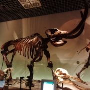
The Mastodon was eventually determined to be a male of about 30 years. Likely, it dates from 11,000 to 13,000 years ago. The team of paleontologists and volunteers were able to recover about 70% of the animal’s skeleton, including the leg bones, shoulder blades, pelvis, skull, vertebrae and ribs. They did not find the tusks, lower jaw and most of the foot bones.  Examination of the remains indicated that there was, in fact, human “interaction” with the animal soon after its death.  For this reason, it was expected that the tusks would not be found at the site.

The leader of the site investigation said fewer than 10 of the roughly 300 Mastodon skeletons found in Michigan are as complete as this S.O. Drain Mastodon. “This is the most complete Michigan Mastodon skeleton in many decades,” he said in a news release. He estimates an 80% likelihood that humans “processed” the carcass. The site would have been ideal for the storage and preservation of the mastodon meat. Eventually, the team will radiocarbon date the remains and examine them for signs of butchery. The animal’s wisdom teeth will also be analyzed to try to determine in which season it died.
Considerable excitement accompanied the dig as volunteers and University of Michigan Paleontologists continued to find bone after bone of the animal. As mentioned above, a considerable amount of the animal was found. In fact, this animal is the second most complete Mastodon found since 1940.  The excavation foreman even participated in the dig.  After noticing the researchers bypass a seemingly ordinary rock repeatedly, he bent down to examine the “rock” and found it very light weight. Surprised at the anomalous density of it, he called over one of the researchers, who excitedly declared it a missing kneecap of the animal. This, I am told, is an important principle of paleontology.  “It’s better to be lucky than good!”
Among the first officials brought into confidence was the Tuscola County Drain Commissioner, Mr. Mantey.  Having the animal falling out of the banks of his facility did concern the Center.  Mr. Mantey was sworn to secrecy until the Center could prepare for the site investigation.  The Drain Commissioner worked out his obligations to the Drainage District and he researched the regulations governing the activities to share with the Fowler Center.  The bank erosion was one of the reasons for the find, so Mr. Mantey requested that the excavator repair the site erosion once the investigation was done.  Then as the Approved Public Agency responsible for soil erosion control, the Drain Commission accepted jurisdiction over the approximately 1/10th acre site during the excavation.

After the excavation was complete, The Fowler Center donated the bones to the University of Michigan Museum of Paleontology.  They also have plans to erect a commemorative sign on site containing an explanation of the discovery.  The site will remain one of the Center’s popular student (camper) activity.  And the story of the uncovering of the fossil remains of one of these impressive animals will be celebrated for years to come.

“Why Wasn’t a Survey Done?!!”

Robert J. Arnold, P.S.

This week I received an interesting question from one of my contacts in the real estate sales industry concerning the difference between a legal description and a Boundary Survey.  Specifically, they were questioning how it is that a legal description can be written when creating a new parcel out of a parent tract (commonly referred to as splitting land) without having a boundary survey completed.

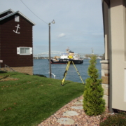
It all started from a quote that I had prepared for a boundary survey of a parcel with the following legal description:  “Commencing at intersection of center line of Lake Shore Road, now Huron Shore Pike, with the East and West quarter line of Section 15, Town 12 North, Range 16 East, thence Northerly along center line of said road 123.25 feet, thence East to Lake Huron, thence Southerly along said Lake to said quarter line, thence West along quarter line to the place of beginning, being part of South part of the Northeast quarter of Section 15, Town 12 North, Range 16 East, subject to the right of way of aforesaid Huron Shore Pike as widened, and subject to any restrictions of record.”

There are plenty of problems with this description, but the question only surfaces because the real estate agent is, understandably, trying to minimize the costs of the transaction by locating a survey that had been previously completed.  Their investigation led them to the revelation that the parcel adjacent to the north of the one they are preparing to sell is owned by the brother of the client and that the parcels were created from a parent parcel as part of the settlement of an estate.  Since the parcels were created simultaneously, shouldn’t there have been a survey done to define the limits of title?  The short answer is emphatically YES!

The long answer is, well …. LONG, and really only an educated guess without having discussions with the parties involved.  There is, however, a relatively common scenario and it goes a little like this:  The heirs of an estate are given shares of a parcel.  Since the heirs are likely family members who will be inheriting both property and money, (which they would rather spend on other things besides a survey), why “waste” the money on having the property surveyed and split properly, especially when the governing municipality and county don’t require having a survey done to split property!  “Let’s just do it on paper”.

At the time, no one dissuades the parties from taking this course of action – not the executor, not the township assessor, not even close family and friends, because we all know the relationship between the heirs will never change…. that is, until they do.

The most common change occurs when one of the original heirs wants to sell what they have inherited.  Once new parties are brought into the situation, all of a sudden it is imperative to define what does and does not belong to each parcel.  Unfortunately, due to the decisions that were made during the divesting of the estate, the sellers could be faced with an additional cost to have the parcel surveyed for the potential buyer.  With vague legal descriptions to start with, chances are very good that issues will be found that need a resolution.  Hopefully, the surveyor that gets hired completes a well-reasoned boundary survey and doesn’t just stake the deed.  That could open up another can of worms………